Tide heights in the Thames area
Conversion table
The table to the right shows the relationship between tide heights published by OceanFun prior to September 2011, and the heights we have been publishing since that date.If you wish to print the chart, best results will be obtained by downloading the PDF file and printing that.
Revised tidebook pages
We have produced an entirely new set of pages for the "Coromandel - Bay Of Plenty - Raglan" tide pocketbook. These pages show the same information as the book you purchased, along with the heights as they would have been under the old tide height regime. The files are in PDF format which can be either viewed online or downloaded. There are two versions; this one is bigger and more suitable for viewing online, or for printing a larger A4 sized page per month. A second version is the original size and should be used if you wish to reprint the pages at the original size, which can be done by using the Print function in your PDF reader.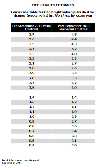
Copyright © 2017 - 2026 OceanFun Publishing Ltd. All rights reserved. Reproduction of this page
in whole or in part in any form or medium without the express written permission
of OceanFun Publishing Ltd. is prohibited.
Please read our Terms and Conditions.
This site is optimised for Mozilla FireFox, and tested with most other popular browsers.